Gunung Sindoro, Central Java, Indonesia

Gunung Sumbing (3371m) as seen from Gunung Sindoro summit
Gunung Sindoro (3153m) is a stratovolcano in central Java, Indonesia. It is also known as Mount (Gunung) Sundoro, Mount Sendoro and Mount Sindara. It's conical peaked neighbour Gunung Sumbing is seperated by the Kledung Pass at 1,404m altitude and from the village of Kledung you can find the Pos or checkpost at what is known as the basecamp or one of the two start points for the trek to the summit. The other start point is found at the base of the northern flank at a village called Sigedang which is more convenient if you are around the Dieng Plateau region.


Mount Sumbing from the slopes of Mount Sindoro at sunrise


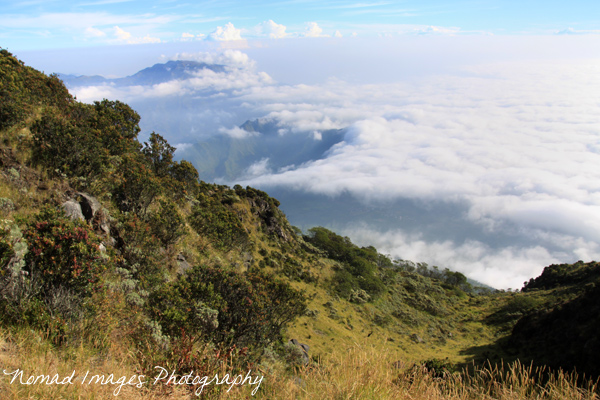
Dieng Plateau from Gunung Sindoro Summit
From Kledung village at the checkpost you must pay about 3000IDR for the entrance fee and also sign the book so it is known you are on the mountain just in case anything goes wrong. Again the path is not at all difficult to follow hence there is no need for a guide. From Kledung to the summit takes between 5 and 6 hours depending on how many breaks you take along the way and how fast you ascend.


Flyers at the Sindoro basecamp in Kledung
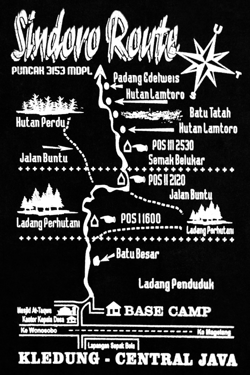
Gunung Sindoro Trekking Map
If you decide to do the ascent in the early morning you may be lucky enough to find an enterprising local who will give you a lift or act as an ojek (motorbike taxi) to take you from 1,404m to the end of the cobbled road at 1,654m whereby you start walking up through the forest, much of which is pine in the early stages on a well defined track. I would advise though to do this at night when it is cooler, whereby you need less water and can arrive at the summit for the surreal sunrise, other benefits include a much better chance of clear panoramic views which are much less likely as the day goes on and the clouds race in! I departed from Kledung around mid-night and arrived for the first rays of the morning sun just after 5.30am.
Advancing clouds, Dieng Plateau around 8am!
The path through the forest takes you firstly, having left the plantations behind to Pos 1 (1,750m) and climbs steadily upwards over a few fallen tree trunks along the way and couple of small log bridges through the undergrowth past Batu Besar or Big Rock to Pos 2 (2,120m). From here the route becomes increasingly steeper until you reach Pos 3 (2500m). The hike is pretty straight forward upto this point but from herein as you ascend further the trees give way to more shrubby plants and rocky terrain where narrow channels from which to gain a footing are the norm and can be slippery when dry due to the dusty nature of it. This poses more of a problem on the descent when dust and small volcanic pebbles make it feel like you are walking on marbles at times, very difficult to even stay upright! In the evening when the air becomes much cooler than in the day dew covers the ground and grip on this topsoil is good.
Dieng Plateau and Gunung Slamet (back left) 90km's (50miles) to the west!
From Pos 3 the path climbs steeply now with vegetation becoming sparse and trees have given way to much more shrubby flora. The views really open up from here and even during the night if there is a slither of moon and the sky is clear you are blessed with views of towering Gunung Sumbing over the way and twinkling lights far far below you. The air becomes increasingly cooler and the breath quickens as you constantly grapple with rocky ground which the route leads you through and now is the time for false summits! During the night when all you have is a headlamp to light the way the false summits are more deceiving, you think this one must be the top and then another and another, long wild grasses carpet the mountainside now and huge rocks jut out from inconceivable places as you march on until eventually as dawn breaks you can clearly see a straight and final path to the summit through beautiful alpine like meadows on the steep incline.
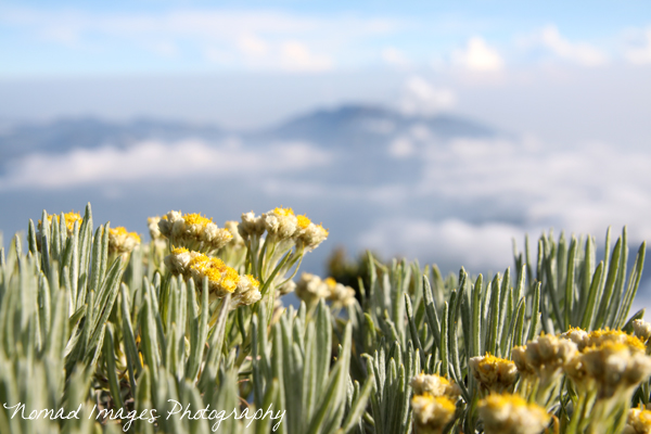
Alpine flora on the slopes of Gunung Sindoro
Mount Sumbing from the slopes of Mount Sindoro at sunrise
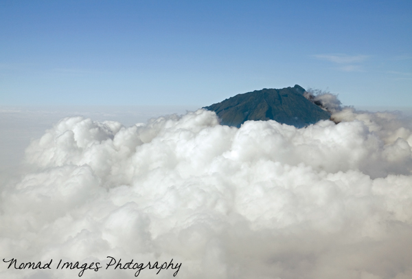
At the summit of Gunung Sindoro (3153m) you will find a sizeable crater which is actually made up of two, a deeper one where sulphurous gases rush out in a couple of places quite reminiscent of a pressure cooker blowing its top and a second more shallower crater within this. The route around the crater rim is a very good well trodden path and going anticlockwise is the fastest way to get beyond the crater and onto the grasslands which is known as Alun Alun. This makes a for a great place to camp and don't be surprised if you see a few campers up here on this small and luxuriant plateau. As you walk to Alun Alun around the crater rim if you gaze to the west a sizeable volcanic peak will be on view in good clear weather, this is Gunung Slamet (3,428m) the second highest Volcano in Java, Gunung Semeru (3,676m) being the highest.
Gunung Slamet 90km's beyond the crater of Gunung Sindoro
Alun Alun plateau on summit of Gunung Sindoro
From Alun Alun you can choose descend to Sigedang and the Dieng Plateau which is pretty steep and slippery due to the dry dusty conditions and small pebble like volcanic stones or retrace your steps back down to Kledung. The Ascent to the summit from Sigedang is said to take less time due to the starting point altitude being 1,900m and the route being steeper and therefore shorter. For fast hikers around 4 hours has been quoted for the uphill hike. I myself descended back to Kledung as I was residing at Bandungan nearby Ambarawa. As the morning wore on the heat picked up and by 9am the clouds obliterated all views of the landscape far below.
Dieng Plateau swamped in cloud at 9am!
Slip sliding my way back down to Kledung took around 3/4 hours of constant pounding on the knees and became a struggle to remain upright with the marble madness caused by tiny volcanic stones and the dry dusty earth with which I had to negotiate my way back down the mountainside. Views were non-existant due to cloud cover which I descended into and the landscape and thick dank forest further down below had an eerie feel too it.
Gunung Sumbing overtaken by the clouds
If you compare the introductory shot of Gunung Sumbing at sunrise to the shot we have above which was taken at around 9am you can see what a difference time and climatic conditions can create around these towering volcanic peaks. My recommendation would be during the summer months when it is the dry season try and hike during the night or if you hike in the day camp for one night so you can catch the remarkable sunrise the following morning before the clouds obscure the views, you won't be dissapointed....
View Larger Map
Interactive Google Maps Location Gunung Sendoro (Gunung Sindoro)