Togakushi Mountain Hike
At last I managed to Climb the famous Mountain that has been looming high over head for months whilst I have been resident in this beautiful part of Japan. But before I tell the tale of the trek lets start with a little bit of history about the place.
Togakushi Mountain (Togakushiyama - 戸隠山) is located beside Mount Takatsuma (Takatsumayama - 高妻山), one of two volcanoes, along with Mt.Izuna situated in Joshinetsu Heights National Park, Nagano Prefecture, Japan. Togakushi itself is a mountain steeped in history. As those familiar with the area know Togakushi was the ancient seat of the Ninja (hence we have the Ninja Museum here too), Togakure-ryū ninpo or The Hidden Door School of Ninjutsu was founded in this area some 900 years ago. Togakure was the name of Togakushi village back in the day when Daisuke Togakure, the defeated samurai warrior escaped to the region. He was taught by Kain Doshi a warrior monk the ways and means of survival in times of violent political turmoil and Togakure Ryu was born.
Togakushi Mountain itself is sacred to Shintoists and Buddhists alike and in the past made the ideal place for deep meditations and contemplations. Therefore there are five Shinto Shrines (akin to temples) in the region.
All of which were founded around a thousand years ago yet the true date remains shrouded in mystery.
Togakushi mountain is sacred due to its place in religious myths associated with the foundation of Japan.
Togakushi mountain range
The trek begins opposite the Togakushi Ninja Museum at the Okusha Tori (gate) which is the entrance to a 15 minute walk whcih takes one through beautiful woodland with streams running either side of the wide avenue like road until one reaches the Koma Inu. Koma-inu (狛犬) are stone guardian lion dogs placed at the entrance to a shrine. A few metres after these one reaches a small building with a thatched roof whcih houses a couple of demon like deities and an open doorway through which one has their first glimpse of the Giant majestic 900 year old (according to some) Redwood Avenue, (Cryptomeria Japonica otherwise known as Sugi in Japanese).
It's a further couple walk steadily climbing uphill to Okusha Shrine or Okush Jinja in Japanese. Okusha shrine is the upper shrine of the three main shrines within Togakushi district. The lower being Houkosha and the middle being at Chusha a couple of Kilometres back down the road as one would travel to Nagano City. These three Shrines, lower, middle and upper are associated with buddhism and the steps devout buddhists take on their journey to attain enlightenment.
Koma Inu with Kuzuryusha shrine in the Background
Okusha Shinto Shrine
Many Shinto and Buddhist pilgrims visit the shrines and at the weekend it can be a very busy place with many Japanese walking to and from Okusha itself and also the adventurous taking to the mountain tops of the Togakushi range. Personally I would recommend if you have a choice to visit during weekdays and avoid the congestion so you can take in the full beauty and tranquility of the surrounding nature at an unhurried pace.
Another adviseable thing to do is pray for a safe journey if you are attempting to scale the heights. Not that I'm a superstitious person but one could do with all the luck possible when undertaking this trek. Togakushi can be a dangerous place if the weather changes which it can do at an alarming rate and many people over the years have come to some mis-fortune. Living in the area one has an idea when somebody has gone missing or had an accident when the mountain rescue helicopter can be heard hovering up above the mountain range.

From Okusha Shrine the well marked and well trodden (though can be slippery when wet) route rises steeply through the forest, many big old Japanese Beech trees (Fagus Japonica - Buna in Japanese) line the path. It's not long before one comes across a huge overhanging rock, Gojikken Nagaya (五十間長屋) next you approach a small shinto shrine within an overhanging cliff face Hyakken Nagaya (百間長屋). At This point the clouds started rolling and I began to imagine the worst and that all hopes of seeing stunning vistas from the top (when I eventually reached there) would be dashed due to the cloud formations.
Shortly after the small shrine comes the start of a succession of steep chain rope climbs, that said I thought it a wonderful thought by whoever put them there to help the hikers, something that one could never expect in the Nepali or Indian Himalaya where one is left to their own devices as dangerous as it may be! The first such chain takes one up to Tengu no Roji (天狗の露地), the goblins garden shortly afterwhich comes another long chain which they call Munetsuki-Iwa (胸突岩).
Within an hour and half after leaving Okusha shrine (time including photo stops) one arrives at the dreaded and fairly dangerous Ari no To-Watari - (蟻の塔渡り) roughly translated as Ants Tower Crossing eluding to the fact that it resembles the precipitous paths along the top of a jagged termite mound for anbody that is familiar with those things. This is where the going gets tough and one has to be careful as this stretch is about 20 metres long by about half a metre wide with a few hundred feet drop either side. I'd already heard tales of this frightening crossing and coming face to face with it did'nt make me feel any better, for those who don't need the adrenaline rush or a dirty great stain in their pants there is a way down beside this point with more chain ropes that make skirting around this hazardous point a bit of a cinch.
Still there is no avoiding the second section which is known as Tsurugi no Ha-Watari (剣の刃渡り), the Swords Blade Crossing, the picture below is of a Japanese guy who was going back down the way I came, highly unusual way to do the trek as it is more treacherous than making ones way across the ridge and down to Bokor Jo or The Cow Ranch. As can be seen he preferred shimmying or shuffling his way across as opposed to crawling on all fours. The picture is taken with a wide angle lens so it gives a false impression as to the width of the Swords blade (knifes edge). The other picture is of me straddled over the knifes edge with the accompanying drop to one side, the other side that is not in the shot is almost exactly the same!!


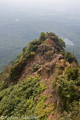
After this point one is almost home and dry at least thats what it feels like but there is then the short steep walk to the top of the ridge and the 1911m post marking Togakushiyama, the trek along the tops through the forest offers fantastic views across to the northern Alps which even at this time of year can still be seen retaining some winter snow and back down into the valley where one can see the outline of the giant redwood avenue leading upto Okusha, Kagame Ike (Mirror lake), Chusha village in the distance and directly opposite, Mount Menou ski area with its ski slopes and Mount Izuna at a similar altitude 1934m behind that.
When the clouds began to lift and skit by the feeling was like that of being on a plane peering thru broken clouds at the landscape far below. From here on in the day turned into a scorcher and all was well with the world
Takatsumayama 2352m (高妻山)
Views of Mount Takatsuma as seen from Togakushi Mountain Ridge as one nears the descending point at the mountain hut. The hut, Ichifudo (一不動), marks a junction where one can continue to trek upto Takatsuma which if the sign board is to be believed is another 150 minutes hiking and another 500m ascent. If one decides to go down to Bokujo (牧場), (Cow Ranch) and the Campsite, it takes between one and one and half hours to reach there. Shortly after leaving the mountain hut one can find a fresh water spring coming out of the mountainside where one can replenish water supplies if needed. Again the chains start but nowhere near as steep as the opposite side leading up to the Knifes edge and not as frequent. The first takes one to a small but beautiful waterfall called Fudotaki (不動滝) and immediately after this one must tread carefully as you negotiate your way horizontally using many small chains across a rock face called Obi-Iwa (帯岩).

One more long chain rope appears on the route to lower oneself down a rather wet and slippery rockface and then it's a lovely but somewhat different world to be trekking through the lush, hot and humid forests on the final leg home, crossing the small stream a number of times as one goes with lots of picturesque spots to take pictures of numerous mini waterfalls.
Campsite at Bokujo
What Next, Takatsumayama????? Watch this space..
Labels: Hiking, Japan, Mountain, Photographs, Togakushi, Togakushiyama, Trek


